logologo
  • Home
  • Apps
  • Games
  • Latest Updated
  • Best Topics
chatbot
logo
  • About Us
  • Disclaimer
  • DMCA
  • Guidance
  • Privacy Policy
  • Terms of Service

Copy Right@snapapk.org. All Rights Reserved.

Google Play™ is a Trademark of Google Inc.

SnapAPK is not affiliated with Google, Android OEMs or Android application developers in any way.

ADVERTISEMENT

Recommend

OpenCPN

OpenCPN

Maps & Navigation

star3.9

ShipAtlas by Maritime Optima

ShipAtlas by Maritime Optima

Productivity

star4.6

Rivercast - River Levels App

Rivercast - River Levels App

Weather

star4.5

i-Boating:UK/Ireland:Marine

i-Boating:UK/Ireland:Marine

Maps & Navigation

star0

Netherland Topo Maps

Netherland Topo Maps

Maps & Navigation

star0

Great Britain Topo Maps

Great Britain Topo Maps

Maps & Navigation

star4.8

Australia Topo Maps

Australia Topo Maps

Maps & Navigation

star4.4

Fishing Points-Lake Depth Maps

Fishing Points-Lake Depth Maps

Sports

star4.2

iNavX: Marine Navigation

iNavX: Marine Navigation

Maps & Navigation

star3.2

Denmark Topo Maps

Denmark Topo Maps

Maps & Navigation

star0

Offline Maps for Travelers - A

Offline Maps for Travelers - A

Travel & Local

star0

WinGPS™ Marine

WinGPS™ Marine

Maps & Navigation

star3.5

OpenCPN

OpenCPN

Maps & Navigation

star3.9

ShipAtlas by Maritime Optima

ShipAtlas by Maritime Optima

Productivity

star4.6

Rivercast - River Levels App

Rivercast - River Levels App

Weather

star4.5

i-Boating:UK/Ireland:Marine

i-Boating:UK/Ireland:Marine

Maps & Navigation

star0

Netherland Topo Maps

Netherland Topo Maps

Maps & Navigation

star0

Great Britain Topo Maps

Great Britain Topo Maps

Maps & Navigation

star4.8

Australia Topo Maps

Australia Topo Maps

Maps & Navigation

star4.4

Fishing Points-Lake Depth Maps

Fishing Points-Lake Depth Maps

Sports

star4.2

iNavX: Marine Navigation

iNavX: Marine Navigation

Maps & Navigation

star3.2

Denmark Topo Maps

Denmark Topo Maps

Maps & Navigation

star0

Offline Maps for Travelers - A

Offline Maps for Travelers - A

Travel & Local

star0

WinGPS™ Marine

WinGPS™ Marine

Maps & Navigation

star3.5

DKW The Netherlands

DKW The Netherlands

Digital charts of the Dutch inland waters with free update service.

5K
Downloads
Free
Price
Google Play
Source
Rating
0.0star
Rating
Safety
100% Safe
Safety
Version
2.06
Version
Category
Travel & Local
Category
Developer
Stentec
Developer
Update on
2023-11-13
Update on

Editor's Review

Navigational app with a subscription service for the Dutch inland water chart 'DKW the Netherlands' with the option to easily create simple routes. Navigating on a tablet or smartphone becomes particularly suitable for sailboats and motorboats as well as dinghies, fisherboats and canoes. ** For only € 15,- you can start using the DKW the Netherlands North or South for a month on an Android tablet or smartphone. With your first subscription you will receive a free 3-day trial period. ** 
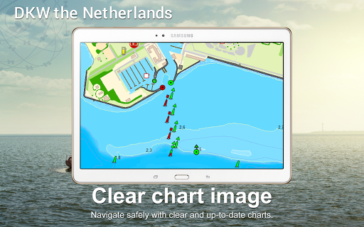
Features of this app 
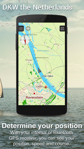
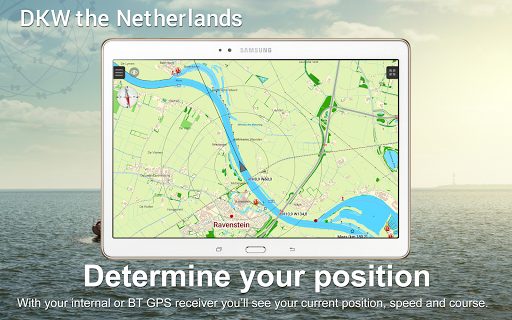
• See current location on the chart and follow automatically. • Record sailed tracks. 
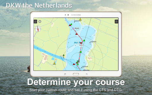
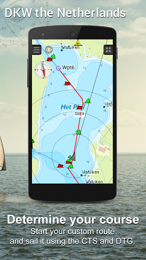
• Make custom waypoints and navigate to them using the route network. • Instrument monitor shows your course (COG), speed (SOG) and GPS coordinates (Lat & Lon). • Also shown are your course to steer (CTS), your distance to go (DTG), total time of your route (TTG) and estimated time of arrival (ETA) to your selected waypoint. • Chart updates will automatically be checked at startup. 
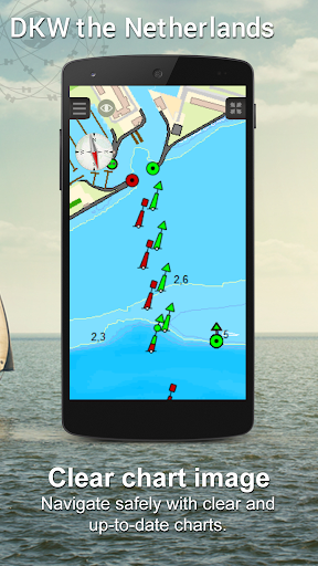
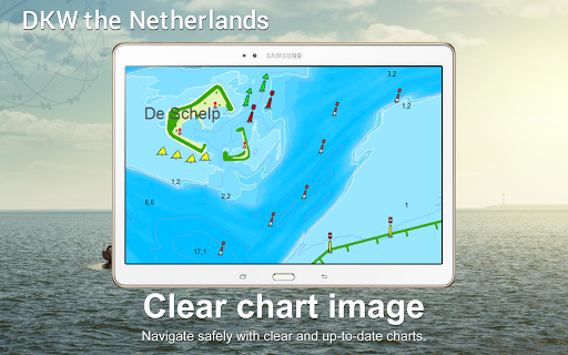
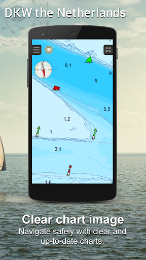
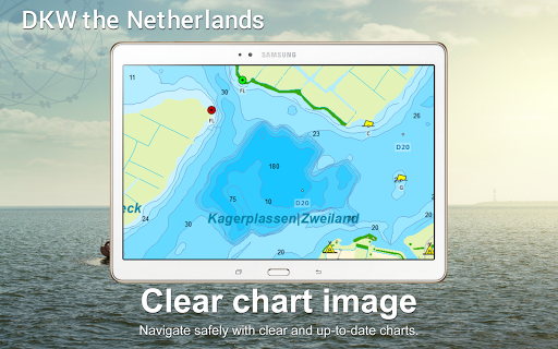
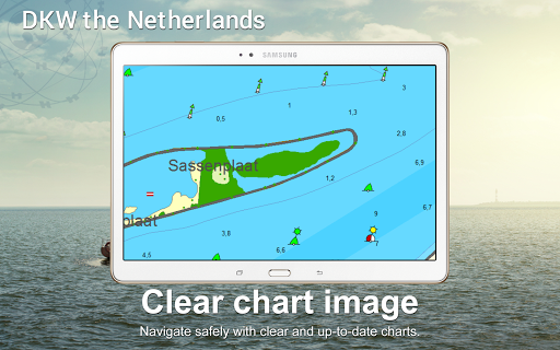
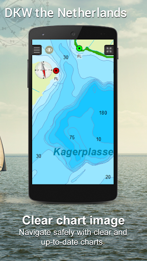
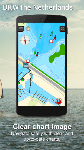
Thanks to the biweekly updates, the accurate surface chart and the help of many long-time users this chart alwats remains up-to-date. With nearly 40.000 waypoints all information on buoys, harbours, berths, diesel filling stations, watersport campings and VHF channels can be found on the chart. With a scale of 2 meter per pixel the chart has a large detailed view and makes it possible to zoom in up until your home port. This chart set has a unique and clear depth image with distinctly colored depth surfaces on the lakes and depth numbers along the waterways. The chart is published annualy by Stentec, based on the Top10NL data from the Kadaster, Inland ENC charts, Rijkswaterstaat and user remarks. To take maximum advantage of this water chart we recommend using it in combination with our WinGPS Marine series. With this extensive navigational app you can turn your Android device into a complete navigation system. Visit www.wingpsmarine.com for more information. More info on subscriptions: Payment is done via Google Play and subscriptions are extended automatically. When you cancel your subscription you will continue to have access to the charts up until the end of your last subscription period. Important note: Your subscription will not be automatically cancelled when you delete the app from your device. You need to cancel your subscription manually. When you remove the app without cancelling your subscription, payments will still continue. For more information on Google Play subscriptions follow this link: https://support.google.com/googleplay/answer/2476088?co=GENIE.Platform%3DAndroid&hl=en
ADVERTISEMENT
Comment
Rate
  • ★
    ★
  • ★
    ★
  • ★
    ★
  • ★
    ★
  • ★
    ★
Please rate this app
Username
Comment

Screenshots

screenshots_0
screenshots_1
screenshots_2
screenshots_3
screenshots_4
screenshots_5
screenshots_6
screenshots_7
screenshots_8
screenshots_9
screenshots_10
screenshots_11
screenshots_12
screenshots_13
screenshots_14
screenshots_15
screenshots_16
screenshots_17
ADVERTISEMENT

Recommend

OpenCPN

OpenCPN

Maps & Navigation

star3.9

ShipAtlas by Maritime Optima

ShipAtlas by Maritime Optima

Productivity

star4.6

Rivercast - River Levels App

Rivercast - River Levels App

Weather

star4.5

i-Boating:UK/Ireland:Marine

i-Boating:UK/Ireland:Marine

Maps & Navigation

star0

Netherland Topo Maps

Netherland Topo Maps

Maps & Navigation

star0

Great Britain Topo Maps

Great Britain Topo Maps

Maps & Navigation

star4.8

Australia Topo Maps

Australia Topo Maps

Maps & Navigation

star4.4

Fishing Points-Lake Depth Maps

Fishing Points-Lake Depth Maps

Sports

star4.2

iNavX: Marine Navigation

iNavX: Marine Navigation

Maps & Navigation

star3.2

Denmark Topo Maps

Denmark Topo Maps

Maps & Navigation

star0

Offline Maps for Travelers - A

Offline Maps for Travelers - A

Travel & Local

star0

WinGPS™ Marine

WinGPS™ Marine

Maps & Navigation

star3.5

OpenCPN

OpenCPN

Maps & Navigation

star3.9

ShipAtlas by Maritime Optima

ShipAtlas by Maritime Optima

Productivity

star4.6

Rivercast - River Levels App

Rivercast - River Levels App

Weather

star4.5

i-Boating:UK/Ireland:Marine

i-Boating:UK/Ireland:Marine

Maps & Navigation

star0

Netherland Topo Maps

Netherland Topo Maps

Maps & Navigation

star0

Great Britain Topo Maps

Great Britain Topo Maps

Maps & Navigation

star4.8

Australia Topo Maps

Australia Topo Maps

Maps & Navigation

star4.4

Fishing Points-Lake Depth Maps

Fishing Points-Lake Depth Maps

Sports

star4.2

iNavX: Marine Navigation

iNavX: Marine Navigation

Maps & Navigation

star3.2

Denmark Topo Maps

Denmark Topo Maps

Maps & Navigation

star0

Offline Maps for Travelers - A

Offline Maps for Travelers - A

Travel & Local

star0

WinGPS™ Marine

WinGPS™ Marine

Maps & Navigation

star3.5