logologo
  • Home
  • Apps
  • Games
  • Latest Updated
  • Best Topics
chatbot
logo
  • About Us
  • Disclaimer
  • DMCA
  • Guidance
  • Privacy Policy
  • Terms of Service

Copy Right@snapapk.org. All Rights Reserved.

Google Play™ is a Trademark of Google Inc.

SnapAPK is not affiliated with Google, Android OEMs or Android application developers in any way.

ADVERTISEMENT

Recommend

TrekMe - GPS trekking offline

TrekMe - GPS trekking offline

Maps & Navigation

star4.1

Topo GPS

Topo GPS

Maps & Navigation

star0

swisstopo

swisstopo

Maps & Navigation

star4.7

CityMaps2Go Offline maps

CityMaps2Go Offline maps

Maps & Navigation

star4.2

Guru Maps — GPS Route Planner

Guru Maps — GPS Route Planner

Travel & Local

star3.9

US Public Lands

US Public Lands

Travel & Local

star3.6

BackCountry Navigator GPS PRO

BackCountry Navigator GPS PRO

Maps & Navigation

star3.8

Explorer - Travel Tracker

Explorer - Travel Tracker

Travel & Local

star0

GOHUNT / GPS Hunting Map

GOHUNT / GPS Hunting Map

Maps & Navigation

star4.5

BackCountry Navigator XE: Topo

BackCountry Navigator XE: Topo

Maps & Navigation

star3.6

Aqua Map - Mobile Chartplotter

Aqua Map - Mobile Chartplotter

Maps & Navigation

star3.4

Garmin ActiveCaptain®

Garmin ActiveCaptain®

Maps & Navigation

star4

TrekMe - GPS trekking offline

TrekMe - GPS trekking offline

Maps & Navigation

star4.1

Topo GPS

Topo GPS

Maps & Navigation

star0

swisstopo

swisstopo

Maps & Navigation

star4.7

CityMaps2Go Offline maps

CityMaps2Go Offline maps

Maps & Navigation

star4.2

Guru Maps — GPS Route Planner

Guru Maps — GPS Route Planner

Travel & Local

star3.9

US Public Lands

US Public Lands

Travel & Local

star3.6

BackCountry Navigator GPS PRO

BackCountry Navigator GPS PRO

Maps & Navigation

star3.8

Explorer - Travel Tracker

Explorer - Travel Tracker

Travel & Local

star0

GOHUNT / GPS Hunting Map

GOHUNT / GPS Hunting Map

Maps & Navigation

star4.5

BackCountry Navigator XE: Topo

BackCountry Navigator XE: Topo

Maps & Navigation

star3.6

Aqua Map - Mobile Chartplotter

Aqua Map - Mobile Chartplotter

Maps & Navigation

star3.4

Garmin ActiveCaptain®

Garmin ActiveCaptain®

Maps & Navigation

star4

Central America Topo Maps

Central America Topo Maps

Central America Topo Maps 1:50.000

100K
Downloads
Free
Price
Google Play
Source
Rating
4.3star
Rating
Safety
100% Safe
Safety
Version
7.1.1
Version
Category
Maps & Navigation
Category
Developer
ATLOGIS Geoinformatics GmbH & Co. KG
Developer
Update on
2023-11-17
Update on

Editor's Review

Easy to use outdoor and navigation app with 1:50.000 topographic maps of Guatemala, Honduras, El Salvador and Nicaragua. This app gives you similar mapping options as you might know from Garmin or Magellan GPS handhelds. Main features for outdoor-navigation: • Create and edit Waypoints • GoTo-Waypoint-Navigation • Create and edit Routes • Route-Navigation (Point-to-Point Navigation) (NOT in this free version !) 
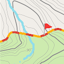
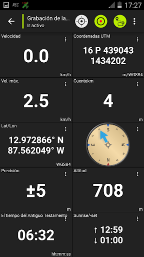
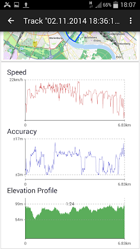
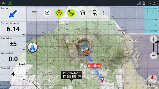
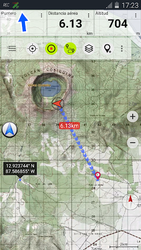
• Track Recording (with speed, elevation and accuracy profile) 
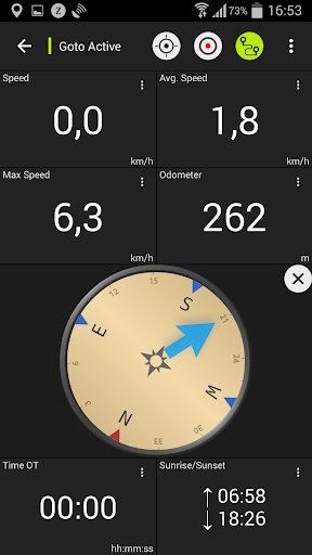
• Tripmaster with fields for odometer, average speed, bearing, elevation, etc. • GPX-Import / Export, KML-Export (NOT in this free version !) 
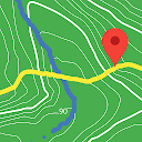
• Search (placenames, POIs, streets) • Customizable datafields in Map View and Tripmaster (e.g. Speed, Distance, Compass, ...) • Share Waypoints, Tracks or Routes (via eMail, Facebook, ..) • and many more ... Available map layers: 
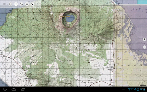
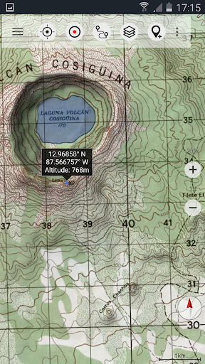
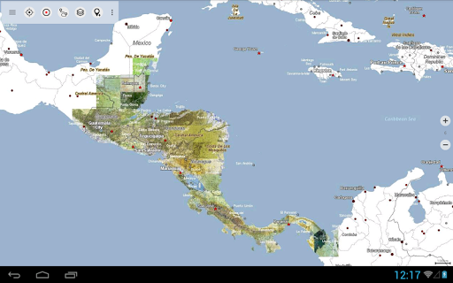
• Topo maps 1:50.000 and 1:250.000 with seamless coverage for Guatemala, Honduras, El Salvador and Nicaragua. Belize, Costa Rica and Panama are covered with 1:250.000 topo maps. 
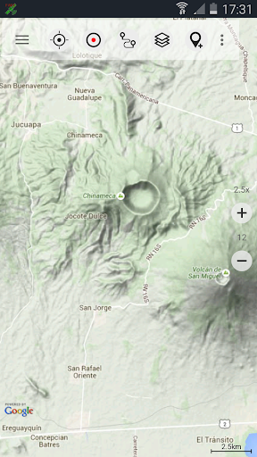
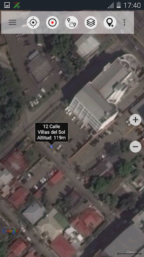
• Google Maps (Satellite images, Road- and Terrain-Map) • Bing Maps (Satellite images, Road-Map) • Open Street Maps (OSM Mapnik and Cloudemade Cyclemap) • Hillshading overlay layer for OSM, Google or Bing maps LIMITATIONS OF THIS FREE VERSION: • Ads • No Bulkdownload of maps for offline usage • No Hillshading overlay • Max. 3 Waypoints • Max. 3 Tracks • No Routes • No import of waypoints and tracks • No Bulkdownload 
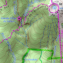
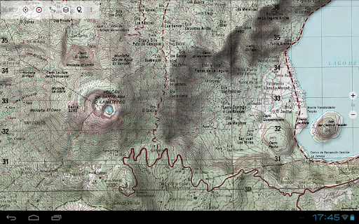
On the 1:50.000 maps you'll find many small roads, pathes and 4WD tracks that are not included in Google, Bing or OpenStreetMaps. The topo maps have a very detailed topography with contour lines. There is no other online mapping service/app available that gives you more detailed geographic features like rivers, lakes, hills, vegetation, villages, etc. for this region. The topo maps layer is a seamless mosaic of more than 1000 georeferenced maps. Although some of the maps are quite old (production range of the maps is 1955 - 2006) they are still very good for outdoor trips, especially if you are looking adventurous routes or abandoned places. Most maps of Guatemala are quite up to date (mostly created in the 90ies) while maps of eastern Nicaragua were created in the 60ies/79ies. Within the app you can open an overview map with the publishing dates of the maps. In larger cities you'll find it more usefull to switch to Google or OSM maps but in the backcountry you will recognize the relevance of large scale topographic maps. The 1:250.000 maps are JOGs (Joint Operations Graphic) which represent a medium scale map intended as both a topographic and an aeronautical chart. Use this navigation app for outdoor activities like hiking, biking, camping, climbing, riding, canoeing or offroad 4WD tours. Preload FREE map data for areas without cell service. The topographic maps are enhanced with Atlogis® hillshading and placenames. Original publisher of the 1:50.000 topo maps : United States NGA (National Geospatial-Intelligence), NIMA (National Imagery and Mapping Agency), DMA (Defense Mapping Agency) Original publisher of the 1:250.000 topo maps: US NGA/NIMA JOG (Joint Operations Graphics) Please send comments and feature requests to camaps@atlogis.com
ADVERTISEMENT
Comment
Rate
  • ★
    ★
  • ★
    ★
  • ★
    ★
  • ★
    ★
  • ★
    ★
Please rate this app
Username
Comment

Screenshots

screenshots_0
screenshots_1
screenshots_2
screenshots_3
screenshots_4
screenshots_5
screenshots_6
screenshots_7
screenshots_8
screenshots_9
screenshots_10
ADVERTISEMENT

Recommend

TrekMe - GPS trekking offline

TrekMe - GPS trekking offline

Maps & Navigation

star4.1

Topo GPS

Topo GPS

Maps & Navigation

star0

swisstopo

swisstopo

Maps & Navigation

star4.7

CityMaps2Go Offline maps

CityMaps2Go Offline maps

Maps & Navigation

star4.2

Guru Maps — GPS Route Planner

Guru Maps — GPS Route Planner

Travel & Local

star3.9

US Public Lands

US Public Lands

Travel & Local

star3.6

BackCountry Navigator GPS PRO

BackCountry Navigator GPS PRO

Maps & Navigation

star3.8

Explorer - Travel Tracker

Explorer - Travel Tracker

Travel & Local

star0

GOHUNT / GPS Hunting Map

GOHUNT / GPS Hunting Map

Maps & Navigation

star4.5

BackCountry Navigator XE: Topo

BackCountry Navigator XE: Topo

Maps & Navigation

star3.6

Aqua Map - Mobile Chartplotter

Aqua Map - Mobile Chartplotter

Maps & Navigation

star3.4

Garmin ActiveCaptain®

Garmin ActiveCaptain®

Maps & Navigation

star4

TrekMe - GPS trekking offline

TrekMe - GPS trekking offline

Maps & Navigation

star4.1

Topo GPS

Topo GPS

Maps & Navigation

star0

swisstopo

swisstopo

Maps & Navigation

star4.7

CityMaps2Go Offline maps

CityMaps2Go Offline maps

Maps & Navigation

star4.2

Guru Maps — GPS Route Planner

Guru Maps — GPS Route Planner

Travel & Local

star3.9

US Public Lands

US Public Lands

Travel & Local

star3.6

BackCountry Navigator GPS PRO

BackCountry Navigator GPS PRO

Maps & Navigation

star3.8

Explorer - Travel Tracker

Explorer - Travel Tracker

Travel & Local

star0

GOHUNT / GPS Hunting Map

GOHUNT / GPS Hunting Map

Maps & Navigation

star4.5

BackCountry Navigator XE: Topo

BackCountry Navigator XE: Topo

Maps & Navigation

star3.6

Aqua Map - Mobile Chartplotter

Aqua Map - Mobile Chartplotter

Maps & Navigation

star3.4

Garmin ActiveCaptain®

Garmin ActiveCaptain®

Maps & Navigation

star4